
Last updated on September 22nd, 2023 at 08:39 pm
I heard about this awesome new hiking area, Window Cliffs State Natural Area in Tennessee, when I was over at Burgess Falls, and rushed right over here!
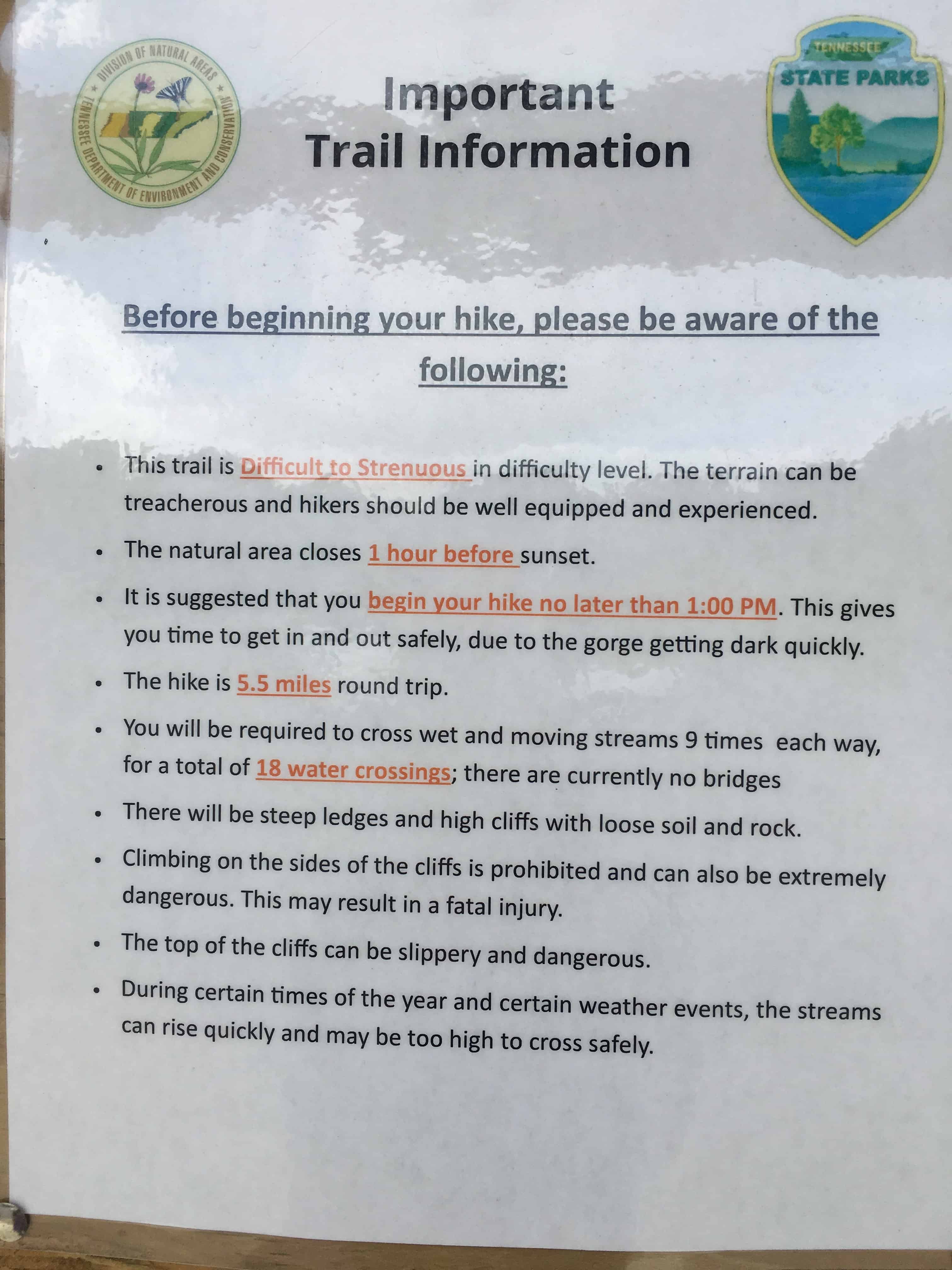
Trailhead Warning
There was only one other car in the parking lot, and I was a little nervous when I saw the sign stating in red underlined and bold letters, “Difficult to Strenuous” hike with 18 water crossings plus steep ledges and high cliffs. Then it warned, “The terrain can be treacherous and hikers should be well equipped and experienced. Of course, I was neither. So I called Sean (who was working, as usual), and told him where I was in case I fell off a cliff and he had to call a search party for me. Then I headed off to give it a try.
The Hike
The hike starts with a fairly steep, zig-zag, wooded descent and I thought to myself, “This is really going to suck coming back.”
At the bottom, I encountered the first water crossing. Each water crossing was marked with a sign and had a cable to hang on to. At this point, I was thinking, “Geez I hope I don’t fall in. I don’t have my waterproof iPhone case.” Since I already lost an iPhone this year due to my clumsiness, I was a little worried. I was also wearing my LL Bean hiking shoes and long pants, but I just rolled them up and went in and slogged along the rest of the hike with wet feet. It actually wasn’t bad and I made it without falling through all nine water crossings!
The trail alternates between wooded sections to open fields, but it is well blazed throughout. I did pass a few people along the way, but overall it was very quiet and peaceful. In addition to the water crossings, along the way I passed a 20-foot waterfall and several cascades.

The last ½ mile was a decent incline, but I still only rate this as moderate, not strenuous. I mean, I’m really not in that great of shape, and I was not huffing and puffing at all. Originally I thought if the hike was too difficult, maybe I could go partway just to get a look, then turn around early. WRONG. You have to go 2.5 miles to get to the overlook. And once you’ve gone that far, why turn back with only ¼ mile left to go?
The Cliffs
So instead of stopping at the overlook, I headed straight for the cliffs. When you get near the end of the trail there is a sign that warns, “Climbing on the top of cliffs is very dangerous.” Right around the corner, you are faced with an even  sterner warning, “Falling will cause injury or death.”
So I’m like ok, it doesn’t say I can’t climb on the top of the cliff. It just says not to fall. I’m pretty sure I can do that. So I did, and there I stood at the top of this unique geological feature 200 feet above a sharp oxbow bend of Cane Creek and it was beyond words! After taking photos (but forgetting a selfie), I sat and stayed a while to drink in the view. Ok, to be honest, I also needed to catch my breath.

I stopped at the overlook on my way back and could not believe the sight of the cliff from a distance. This is where you can really see why the cliffs are named after windows. According to the website, “Window Cliffs is a prominent geological clifftop feature that consists of a very narrow, elongated ridge that lies in the neck of an incised meander of Cane Creek.” Basically, that means the erosion occurs inside the cliffs so they look like windows.

Most of the hike back was a breeze and I got very good at the water crossings. Then I hit the last part, remember the one that was a very steep downhill descent coming in? Yeah, my prediction was right—it sucked going up. Still, I’m so glad that I made this completely unplanned detour. It really was one of the best hikes I’ve ever done!
