
Last updated on January 29th, 2024 at 08:52 pm
On our recent trip to the Phoenix/Mesa area, we decided we wanted to venture out of the city and enjoy some of the beautiful desert scenery. What started as a calm drive through a sea of Saguaro, became a white knuckle drive through one of the most amazing canyons via the historic Apache Trail, aka State Route 88.
About the Apache Trail

Don’t let my introduction scare you off. You can drive the first 25 miles easily and see incredible views of desert plants and trees, wildflowers in season, canyons, lake views, and geologic formations. Coming from Mesa, the first 25 miles are paved and quite safe. You can always turn around at that point if you don’t want to risk the unpaved portion.
The original narrow, rugged trail was converted to transport heavy equipment and supplies a distance of nearly 60 miles from the town of Mesa to the Theodore Roosevelt Dam site. Today the Apache Trail itself is just less than 50 miles. The northern 22 miles of it are unpaved. Because the road is well maintained and graded, 4-wheel drive is not a requirement for this drive. However, there are several switchbacks over sheer cliffs, so it is not for the faint of heart.

Stops on the Apache Trail
We chose to take the full circular route, with stops for restrooms, lunch, and a scenic steamboat tour, and it pretty much took all day. Shortly after starting the drive in Apache Junction, we came upon Goldfield Ghost Town. It is a tourist attraction that revolves around a reconstructed 1890s town including gold-mine tours, Old West gunfights, a history museum & main street. We already had a full day planned, so we passed it by and put it on the list for next time.
Five miles past the ghost town, is the turnoff for Lost Dutchman State Park. This is a great place to spend a day (or more) on its own. There’s a visitor center, campground, mountain bike trail, and several hiking trails.
Continuing along the Apache Trail, we entered Tonto National Forest and began our ascent up through the desert valley on a paved, slightly bumpy winding road. After about 15 minutes, we rounded one of many bends in the road to see our first spectacular view of Canyon Lake.

There’s an interpretive overlook where we stopped to read about this man-made 990-acre reservoir lake. It is one of four that were formed on the Salt River upon construction of Roosevelt Dam at the northern end of the Apache Trail. If you have time, be sure to stop at the marina for lunch, then take the Dolly Steamboat nature cruise. We really enjoyed this 1.5-hour, 6-mile steamboat ride on the secluded inner waterways of this beautiful lake. While listening to the captain recount the legends and lore of the mysterious Superstition Mountains, we saw desert big-horn sheep and numerous birds.

After that wonderful diversion, we continued on the Apache Trail passing Tortilla Flat, the last surviving stagecoach stop along the Apache Trail. Today it has a restaurant, gift store, and small museum all in the “old west” theme. Directly across from the restaurant is a campground open from October through April each year. It and the other camping areas along the Apache Trail are great spots to take advantage of cooler temperatures while you enjoy boating, fishing, hiking, rock climbing, and scenic driving throughout the surrounding Tonto National Forest.
Unpaved Portion of the Apache Trail – White Knuckle Driving
At milepost 222 there is a parking lot with scenic views, walking paths, and restrooms. After this is the point, the most difficult part of the Apache Trail begins. The pavement ends and the remaining dirt road to Roosevelt Dam has plenty of hairpin turns and switch-backs with steep grades. If you are adventurous enough, keep going on this magnificent drive. There is some phenomenal scenery and stunning geological formations along the way! Here you can see where light-colored bands of lava flows have formed huge cliffs. However, the driver will need to keep his or her eyes on the road as the edge of the road drops several hundred to the bottom of the creek bed!

Sean is a great driver and was confident he could navigate the many switchbacks and tight curves we’d encounter on the 1,500-foot descent. I will admit to being pretty scared and hanging onto the door handle as if it would save my life during several of the narrow turns along sheer drop-offs with little to no safety barriers!
Luckily Sean is much calmer under pressure. He got us through it with no problems and we were rewarded with stunning views of beautiful Apache Lake as we drove along it towards Roosevelt Dam. Apache Lake is a man-made reservoir that is about 17 miles long. If you approach Apache Lake from the opposite direction you can pull a boat for fishing or water skiing.

Roosevelt Dam – A Marvel of Engineering
At the head of Lake Roosevelt, you’ll find the 327-foot Roosevelt Dam. We stopped here for a good view of the dam, and to read about it on the interpretive displays.
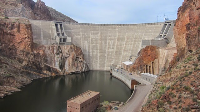
The dam was originally built over a century ago and was the world’s highest masonry dam at 280 feet tall. It was built in a Greco-Roman style by stacking large stones upon each other. The original masonry blocks were encased in concrete during the reclamation project which raised the dam to its current height.
On the other side of the dam is the Roosevelt Lake Bridge, the longest two-lane, single-span, steel-arch bridge in North America. The bridge spans 1,080 feet across Roosevelt Lake providing two-way traffic.

Prior to the completion of the bridge in October 1990, traffic drove over the top of the dam. The original dam-top roadway was designed to allow two Model-T Fords to pass abreast. The Visitor Center at Lake Roosevelt is a great place to stop and stretch your legs. There are several large exhibits including plenty of history about the Roosevelt Dam and surrounding area, videos, and displays of local flora and fauna.
Another good spot to visit is Tonto National Monument, which has well-preserved cliff dwellings that were occupied by the Salado during the 13th, 14th, and early 15th centuries. Stop in at the visitor’s center first to see the interesting displays and talk to the very knowledgeable staff. Afterward, you can climb a steep but short paved path to see the structures. There is a docent at the dwellings and you can actually walk through the site instead of just looking from a distance. If you plan ahead, you can sign up for a guided hike to the upper cliff dwelling. The trail is about 3 miles roundtrip, but the guide stops to let folks catch their breath and talk about the Salado people who built the dwellings, the development of the park, the vegetation, and wildlife, and answer questions. Unfortunately, we arrived too late for this hike, but it is definitely on the list for our next visit!
Explore the Local Area
This is a great day trip from Mesa, Phoenix, or Scottsdale. We had so many adventures in Phoenix on our last trip that we’ve decided to explore Scottsdale on our next one. From horseback riding and hot air balloons to the Desert Botanical Garden, you can find some of the best things to do in Scottsdale.
Sharing is Caring! Feel free to share this article on social media or save the image below to Pinterest.


[…] It is truly a natural playground, and any Phoenix visitor should check it out. It’s a must-see stop along the Apache Trail scenic drive. […]